Thursday 25th July.
In the morning I went for a walk to the nearby wetlands reserve. I had a nice walk around the perimeter and watched the several groups of Magpie Geese camped on the low mounds around each pond.

It seems they use a group safety system. While some sleep others seem to keep an eye over the flock while others seem to walk around like security guards. If anything causes concern, such as me walking 100 metres away, the walking guards honk while the watchers take up the call and if I get too close such as on the other side of the pond, they all take off, in silence, except for the noise of hundreds of wings flapping. Then on some signal they all land a few hundred metres away and go back to sleeping, watching or walking.
  Sometimes two or more birds take off or some come in to land. Never one bird alone. As there were several such groups, they all carried out the same routine as I approached.
I also caught sight of a pair of Brolgas (Australian Cranes) tippy toeing on the edges of the wetlands trying to be typically secretive as Brolgas appear to do.

I continued my wanderings across the places where I lived and played for many years. Re-visiting, re-living and in some way having a new experience with eyes that see differently.
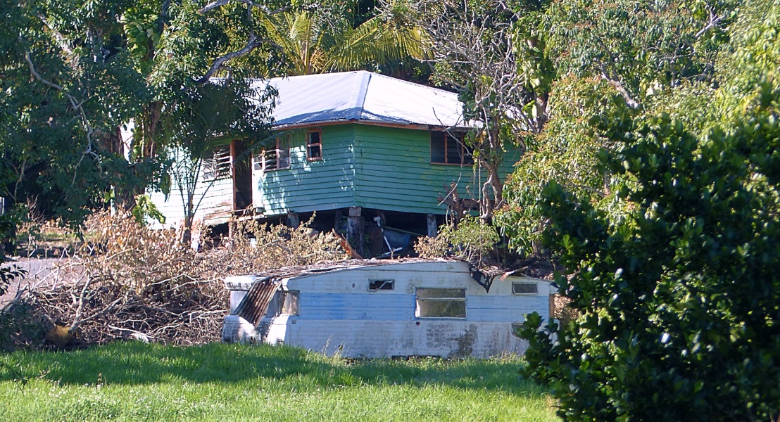
Today I drove through Habana, then onto a gravel rural road to Yakapari and onto the Yakapari to Seaforth Road. Along the way I was also looking for abandoned houses and strange letterboxes.

Often I want to stop when I see one of those items, there is nowhere to park the car and when I do find a place, the prospect of hiking back to the site does not appeal. At least in most cases it is on rural back-roads so frequent stopping is OK but trying to slow down and stop on a more populated road or even a main highway is nigh on impossible.

Today I turned off just before Seaforth and drove to the sleepy village of Ball Bay. Most of the village is made up of permanents and the rest are weekenders. What quickly became obvious is this is a town where all the NO signs grow. No Parking, No camping, No stopping, No water, with other signs which ask you to report suspicious behaviour. Perhaps drug smugglers use the beach to umm err, smuggle.
The beach is a wide arc of rough muddy sand and looks uninviting at low tide and it seems everywhere I have gone these last three weeks it is low tide. Ball Bay has no appeal for me and I felt disinclined to photograph anything.
The village has no shops or other services. They have telephone but no town water or sewerage. They do have garbage collection.
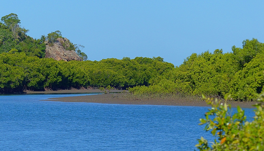
After leaving Ball Bay I stopped to look at a rock feature which is the tall peak of an ancient volcanic caldera.

We have always called them jump ups but in reality are just the remains of the volcanic walls which have eroded at a slower pace than other parts. Looking at a Google Earth Photo it is plain to see the caldera outline with Ball Bay nestled into the sea side opening.
https://www.google.com.au/maps/@-20.9126421,148.9927266,4173m/data=!3m1!1e3?hl=en
Next stop was the little campground controlled by Queensland Parks and Wildlife at Smalley’s Beach.
There are only 11 sites, all screened from each other by trees and shrubs and all with a view through those trees to the beach.

I should mention the beach here is mainly shell grit but at the top of the beach the sand is more like a fine layer of clinging dust. Most of the beaches in this area have a similar dust like sand at the approach to the beach.

There is a view across the coral sea to some of the lower Whitsunday Islands across a normally calm and placid expanse of sea. The southern end of the beach is covered with small boulders which seem to be remnants of spewed volcanic material from an insanely distant fiery past.

There are no facilities here so campers need to be self sufficient and must take all their rubbish with them as there are no garbage facilities either. Interestingly the people who come here are more often from overseas and have found the location by diligent research. Most Mackay locals would not have heard the name and if they have, could not tell you where it is. We camped here in our first motorhome, a converted Toyota Coaster bus way back in 2005. It is quite simply a congenial place to sit back, do nothing and veg out type of place. If you can find them, talk with your neighbours.

Next up was Belmunda Beach.

This location is poorly signposted and is on a rough gravel road after turning off from another dry and dusty gravel road. It passes through two types of landscape. Sugar cane stretching off into the distance and low scrub on flat salt/clay pans in a flood prone zone.

Belmunda Beach is on a raised hillside above the low lying marsh area.
People who live or weekend here need to be self sufficient. Most houses are really nothing more than rough huts. There is no electricity, no water, no sewerage and no garbage collection. I saw one sign to say the property was for sale and the main selling feature was the 12 volt system powered by batteries and solar panels. The tiny village is cut off during the annual wet season when flooding rain turns the normally placid Knobbies Creek into a kilometres wide angry raging flood.

To live here you need to be comfortable in your own skin and or hiding from the world. Or hiding from the law. Or both. There is not much to see or do here except fish. There are no facilities, not even a bench seat to have a lunch or even just somewhere to sit. Unlike Ball Bay there are no NO PARKING signs. In fact there is an absence of signs – unlike Ball Bay.

Along the way I saw several abandoned houses worthy of stopping and taking photos.
By the way, it is mid winter and the temperature was around 24° with very little humidity. It is ideal weather except for the chilly south easterly breeze in the open.
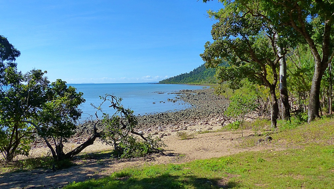
From a high point on the high point of Belmunda I could see Cape Hillsborough across the bay in the distance. Then I saw what looked like a giant archway which I have never seen before and in fact did not know it existed.

What the!!!
I thought maybe it was an optical illusion but it is real. I needed to do quite a lot of research and thanks to The Mackay Bushwalkers Club, Message Stick news letter I now know it seems there is no official name on a map. The Bushwalkers call it Cape Hillsborough Arch and Sea Cave. It seems even some of their members did not know it existed either. More details can be found here. https://www.mackay.bwq.org.au/Newsletters/August_2014.pdf and again here https://www.mackay.bwq.org.au/Newsletters/September_2015.pdf
Also from here I had a clear view of Brampton and Carlisle Islands. Here is a little video about Brampton.
Considering what I thought was a lack of something to photograph I still managed to take 94 photos today.
On the weight loss program I am pleased to announce my weight is now down to 74.3 Kg. My target? 72 Kg or less.
Friday 26th July
I spent the morning downloading photos, on-line research and writing up my notes from yesterday. Initially I thought I would spend all day doing the photos but the weather is so nice I decided it was time to get out.
I drove to Shoal Point and a little dirt road which leads to Hodges place, a property with many acres surrounding a house on a spit of land which could get washed away if it were not for the original Hodges building a huge rock wall near the house site. I found a parking spot just outside the fence and gates with the Private Property, No Entry signs posted. Another three cars were also parked here. It is not such a secret location. I had decided to walk to Reliance Creek to see what devastation has occurred over the last XX years. The walk from where I parked the car to the mouth of Reliance Creek is about 1 Klm.

I should mention that between Shoal Point and Cape Hillsborough are three major creeks draining into the shallow Sand Bay. Reliance Creek is the first. It is quite a trudge along the beach at low tide as there are many obstacles of loose sand, shell grit, exposed dead roots of dead mangrove forests, deep mud, rocks and during the day the dry sand gets very hot on bare feet. The grittiness of the sand caused a blister on a big toe.
In September 2018 I walked most of the way and reported on a car which somehow manged to be driven to where it was finally bogged and irretrievable.

I can report the car is still there although there is much less of it now. I pushed on until I reached the mouth, which at the moment was a wide expanse of sand due to being at the bottom end of the tide.

In 6 hours where I was standing would be under water as a 7 metre tide range returns.

It was quite eerie standing there below the bank with mangroves, mud banks and sand sand sand in all directions.

That and of course the knowledge this creek is a well known spot for Crocodiles.


My exploration was brief as in places the sand was deceptively soft and or like a quicksand with a very damp mud beneath the recently laid down surface of sand. I had not told anybody where I was going so I needed to take care. Not only Crocodiles live here but so do sharks, stingrays, stonefish, a variety of snakes and legions of mosquitoes and sandflies.